After our interesting Maori camping experience, we decided to go to the very north tip of the north island. Make sure you fill up. It’s a long way out there!

All the way at the end of the road is Cape Reinga. The drive there was really beautiful. This is the view looking back toward the Tasman Sea.

This is where the South Pacific Ocean meets the Tasman Sea. The lighthouse is at Latitude 34 South and Longitude 172 East.

Smile!

This is a very sacred place for the Maori people. They believe that when they die their spirits depart for the underworld by sliding down the roots of the pohutukawa tree and into the sea below.

The South Pole is 6211 kilometers to the south. The Equator is 3827 kilometers to the north. Los Angeles is 10479 kilometers to the northeast.

There is a stretch of golden sand that runs up the west coast called 90 mile beach. In reality the beach is only about 60 miles long. If you choose to drive along the beach this is where you take off from the main road to the 4WD sand “road”. Even though many people drive along this beach it is very risky because of the pockets of quick sand. Yikes!

Only 3km south of the cape is a beautiful beach camping ground called Tapotupotu Bay. Of course we stayed here and went for a swim the next morning.

The next night we moved onto another beautiful beach camping ground on the karikari peninsula. This one is Maitai Bay.

Beautiful!

A little further south on the northland is a small town named Kerikeri. This is a town known for it’s citrus growing. There is a bit of history here too. This is the Stone Store built in 1835. It’s New Zealand’s oldest stone building.

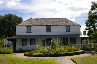
This is the Kemp House also known as the Mission House built in 1822. This house has gone through many changes during its life. There was a major flood in 1981 that inspired an "authentic" restoration. Since only the lower level flooded it was restored to the original style of its Missionary days and the upper level was kept as Victorian.
We found another great camping ground a little north of Kerikeri. This is the view of Matauri Bay from the ridge.

Happy Valentine’s Day! Squiggles for Ang! So yummy!

Waitangi is one of the most important places in the country. This protected area is known as the Waitangi National Trust Estate. This is where the Treaty of Waitangi was signed. It is a treaty between the Maori people and England. In the 1830s the French were beginning to show interest in New Zealand. The Maori people wanted extra protection. Through a series of conversations came the Treaty of Waitangi where England was able to emigrate here and Maori were give the protection of “the crown” England. This is the spot where the Treaty of Waitangi was signed on February 6, 1840. New Zealand became part of the British empire.

Every year on February 6 there is a big celebration, Waitangi Day. They take out their wakas (war canoes) to celebrate.

This is the Treaty House. Now it’s used as a museum for artifacts from the 1800s.

The Maori meeting house called Whare Runanga. Each Maori tribe from all over New Zealand is represented here. This is part of the wall and part of the ceiling.

A beautiful lunch spot at Long Beach on Oneroa Bay.

Black Betty is enjoying some sun.

The small town of Russell used to be known as the “Hellhole of the Pacific”. Many sailors and whalers would gather here and create a ruckus. This is the view of the town from Flagstaff Hill.

This is the oldest church in New Zealand called Christ Church, built in 1836.

Another beautiful beach to camp by, Otamure Beach.

The waves crashing at Otamure Beach.

There is a marine reserve by Goat Island. People hire (kiwi for rent) snorkel equipment to view the abundance of marine life in the water. Unfortunately the cyclone just north of New Zealand stirred up the water so it was too murky to see anything under the water. But this is the beautiful coastline above the water.

This is called Goat Island because the original British explorers didn’t find any fresh water on the island. They call any island with those characteristics goat island because only goats can survive. Interesting!